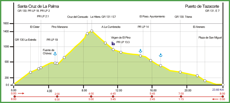
- Niveau de difficulté: Moyen. The path makes for easy going, the main difficulty being the considerable height differences involved.
- Distance totale: 23.60 kms.
- Dénivelée positive: 1510 mt.
- Dénivelée négative: 1510 mt.
- Durée prévue (aller): 08:00 hrs.
- Durée prévue (retour): 08:00 hrs.
- Période Recommendée: All year round.
- Comment arriver au départ?: There is a bus service.
- Recommandations: Habitual precautions common to hiking in general are listed below. At the risk of sounding obvious, here are some of the most important:
- Check weather forecasts before setting off to hike.
- Don´t go alone
- Tell someone your intended destination and expected time of arrival
- Carry a small rucksack with warm clothing, waterproofs, food and plenty of water.
- Don´t forget such simple items as: sun hat, protective cream and sun glasses.
- Carry a mobile phone with fully-charged battery, a map and, if possible, a compass. They will probably never be used but, when required, are of vital importance.
- Wear suitable gear, especially footwear: trekking boots or similar are essential, trainers or pumps are to be avoided.
- Autres remarques: From El Paso onwards, practically the entire length of the path is asphalted. The strategic course of the old Camino Real has been exploited and converted into a road. Certain sections carry heavy traffic and are thus potentially dangerous, especially the Hermosilla zone. Many walkers therefore opt for ending the hike in El Paso, even though that implies mutilating the historical essence of the route. If wishing to walk the full length of this route, the best day to do so is Sunday: on weekdays, especially at rush hour, the number – and speed – of passing vehicles is extremely high. In view of the situation, work is in progress on an alternative to the old path, to enable walkers to reach Puerto de Tazacorte with less trouble.

